EURA 2023 – Mobile workshops themes

UR&P Journal – Editorial Team Meeting, Budapest
23/05/2023
#54 The City of Reykjavík as an urban development toolbox: a glance at EURA2023
31/05/2023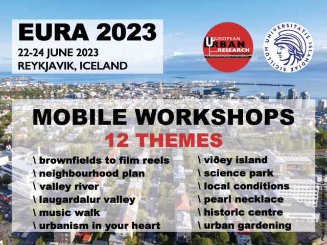
EURA 2023
Walkshops Themes
As usually happens in EURA conferences, during the first day of EURA 2023 (Thursday afternoon, 22 June), all attendees will have the chance to establish direct contact with some of the interesting urban challenges taking place in Reykjavík. The local organising team has come up with twelve mobile workshop which participants may choose from. For practical reasons all participants need to register for mobile workshops. Registration will open soon and closes 20 June.
All participants meet in front of the University Square building no later than 14h00. Please note the following:
- All tours will start no later than 14h15
- All tours will return to the University Square building around 17h15
- All tours are guided and have minimum and maximum number of participants
- The boat tour to Viðey is dependent on weather
- All transfer times are dependent on traffic
- All tours are reserved for conference participants only
- All tours are booked on first come first served basis
- Registration closes 20 June, 12h00
More details on the EURA 2023 website.

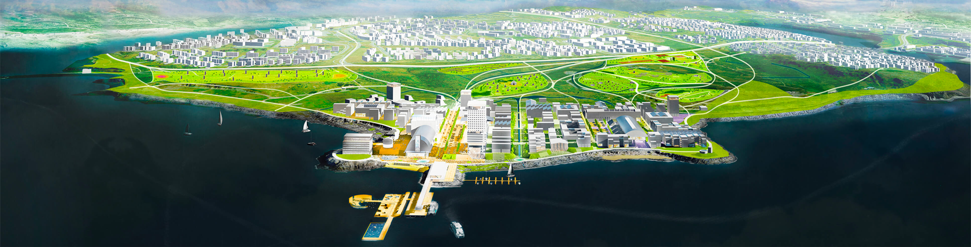
Theme 1 – Brownfields to film reels
The challenges of developing a new creative neighbourhood in Gufunes
Gufunes (Steam Peninsula) is one of the most challenging development areas in the city, where the goal is to create a mix of residence and creative industries in interaction with nature and historical structures. The area has a strong connection to the sea, framed by the coastline on three sides. Here you will find beaches, white sands and rocks, as well as the old pier with its panoramic view of the mountains.
In 1952, the state opened a fertilizer factory in Gufunes, a major industry at the time. The large factory structures, some of which were visible from the city centre, have since made a striking impact on the place. By 1960, the Gufunes bay also became an open scrap heap, later a landfill that stayed open for many years. This has of course changed the look and quality of the environment and polluted the soil. Today, the area has limited connection with public transport, but for decades there have been plans for Sundabraut, a new north-south trunk road running by the district, connecting the city’s northernmost boundary with the centre of the capital area.
Some of the historical structures in Gufunes already serve as film studios for RVK Studios. Other buildings have been redeveloped for various companies associated with film making and other creative industries. We will stroll around the area and learn about its history and future plans, considering myriad challenges and opportunities that come with transforming a former industrial site into a viable, creative neighbourhood. We will meet the people working on the future vision as well as the developers and creative actors that are all playing a part in bringing the vision to life.
Picture: https://www.felixx.nl/projects/transformation-strategy-gufunes.html
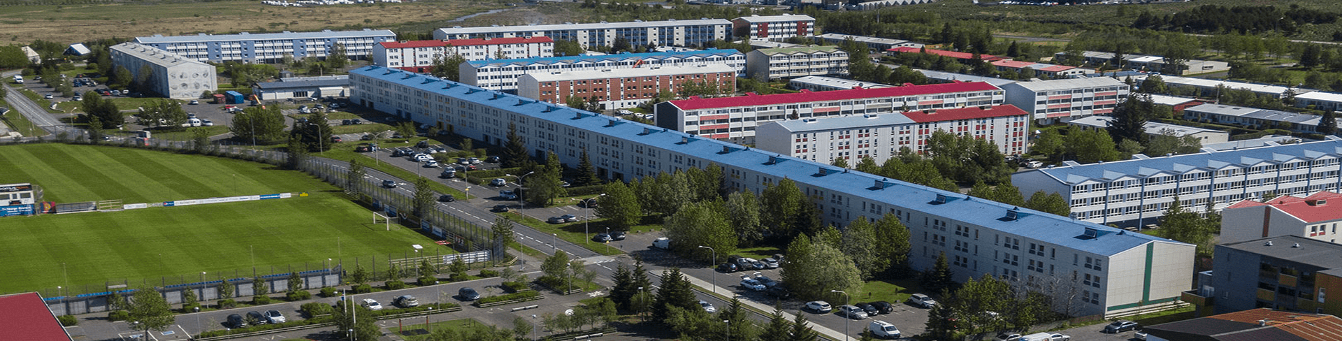
Theme 2 – The Neighbourhood Plan
The challenges of diversity in urban planning
Visit to the district Breiðholt, originally a building development project and the housing complex in Breiðholt in its current form can be traced back to the so-called June agreement in 1964, between the labour movement and employers. There was a housing shortage in Reykjavík and the rental market was particularly difficult. With the development of Breiðholt, it was possible to eradicate slums in Reykjavík and secure safe housing for low-income residents. Buildings cropped up at a new and unprecedented speed in the 1970s and 80s, and Breiðholt soon grew to become the largest district in the Reykjavík municipality. It developed into mixed residence of apartment buildings, terraced, and detached single-family houses. The city of Reykjavík has put a lot of effort in recent years in making Breiðholt a good quality neighbourhood with focus on prevention, social inclusion, and good quality services, after decades of associating the name Breiðholt with social problems.
One of the main topics in this workshop will be The Neighbourhood Plan, which is a new plan intended to make the city’s neighbourhoods more sustainable and environmentally friendly. The Municipal Plan for Reykjavík 2040 presents the framework for the neighbourhood plan and six sectors in Árbær and Breiðholt have already been placed thereunder.
Picture: https://skipulag.reykjavik.is/hverfisskipulag/breidholt/en/throunarsvaedi-i-breidholti/
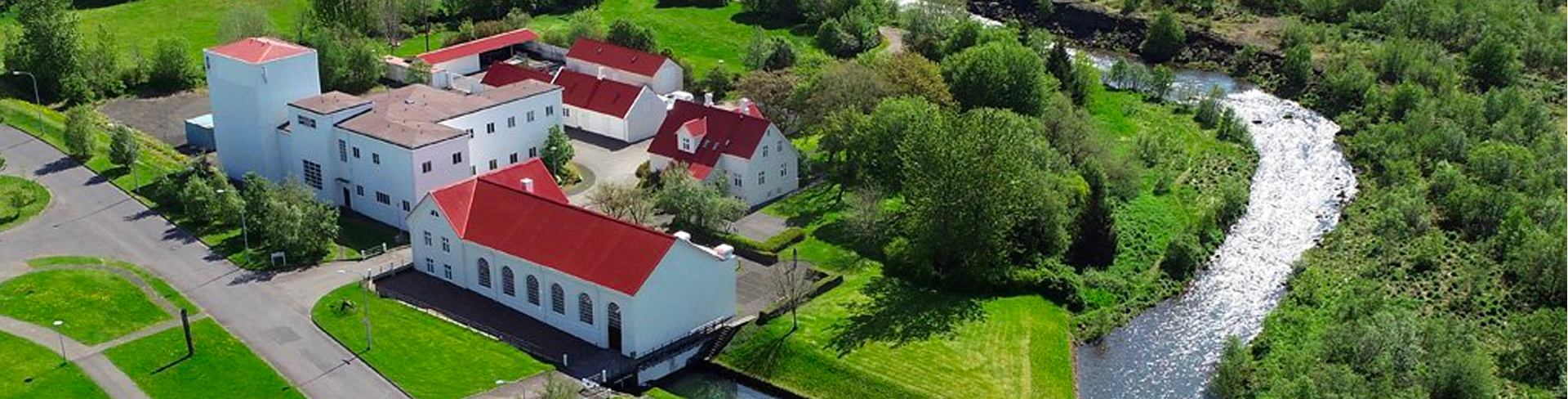
Theme 3 – The Valley River
A story of power generation, urban greening and wild salmon
The walk will circle through the lower east-west section of the Elliðaár valley, meander through woodland and along the riverbanks, past an old dam and empty reservoir, as far afield as time (and weather) will allow for. The group will be joined by experts who can talk about 20th century power generation for Reykjavík, 21st century wastewater works, the structures in use and the structures that have been repurposed for historical and cultural purposes.
The whole valley is popular with residents for outdoor and recreational activities: outdoor gamers, equestrians, cyclists, hikers, runners and dog walkers. We will learn about the life of the valley, rebuilding, greening, re-wilding, hazardous pollutants and a long history of fishing for wild salmon and trout. Beverages will be served at a rest stop before the group heads towards the bus station back to City Centre.
Picture: https://www.or.is/en/environment/outdoor-areas/ellidaardalur/
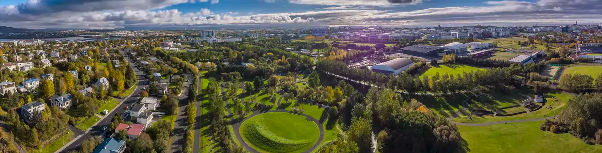
Theme 4 – Laugardalur Valley
From Hot spring Valley to major centre for sports, culture and recreation
Laugardalur Valley has been an influential factor in the development, organisation and culture of the city. The laundry pools in Laugardalur played an important role for decades in the households of Reykjavík.
The roots of Hitaveita Reykjavíkur (Reykjavík Geothermal Energy Company) lie in the existence of these pools and the oldest pumping station still stands on the grounds. The pools were a forerunner to the massive heating system projects, undertaken at the beginning of the 1950s. Organised swimming lessons began in the pools in Laugardalur around 1824, and the painter Sigurður Guðmundsson made a plan for the sports and outdoor recreational area in Laugardalur for the people of Reykjavík, where he proved to be far ahead of his time. Developments in Laugardalur are intertwined with the sporting history of Reykjavík and the country.
Picture: https://reykjavik.is/en/laugardalur
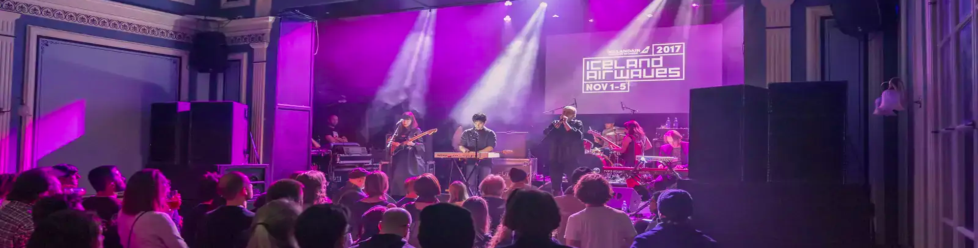
Theme 5 – Reykjavik Music Walk
Culture as foundation
Reykjavík is a relatively small city, and its size naturally shapes its music culture. Everything is in close proximity: venues, institutions and practice spaces, especially if we focus on the 101 area. The shortage of clubs and venues throughout the years has a hidden, positive dynamic, as this has fortified the city’s music scene at each given time and often led different musicians together, something that is near impossible in big cities of millions.
The 101 area has been the centre of Icelandic music activities for a long time, giving way to music festivals, concerts and general “hang-outs” for musicians in form of bars and cafés. Thus, the Reykjavík Music Walk Tour focuses on Iceland’s pop and rock history and the landmark sites that have contributed to its remarkable success abroad and domestically. E.g., the downtown practice spaces of Björk and The Sugarcubes, concert halls used by early career Sigur Rós, historically important live venues and artist hangouts.
The walk is guided by Arnar Eggert, Iceland’s foremost popular music historian and journalist. Arnar can answer any questions that people might have about the fertile Icelandic music scene.
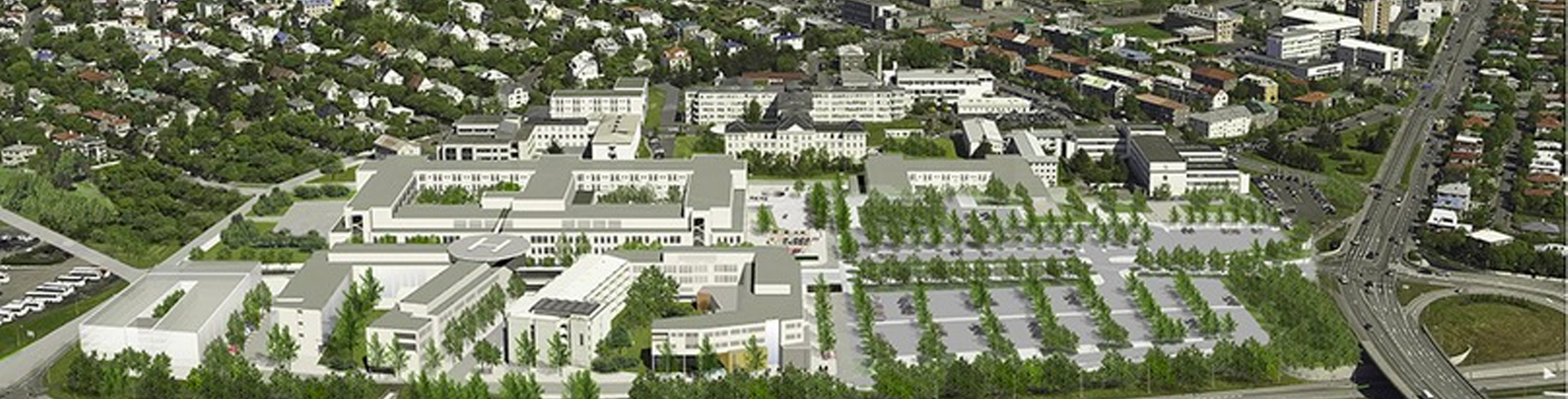
Theme 6 – Urbanism in your heart
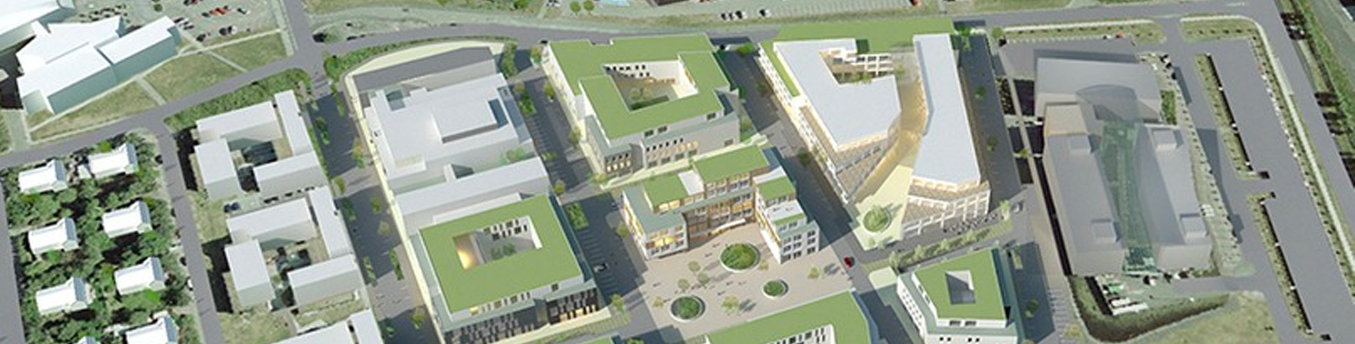
The area of the National University Hospital of Iceland is the largest and at the same time the most complex construction and development site within the city centre. A new high-tech hospital is now being built within already established structures in the vicinity of the city’s natural habitats of Vatnsmýri Nature Reserve and Öskjuhlíð hillock. The volume of this construction, including a state-of-the-art Laboratory Centre and Faculty of Medicine, is around 150.000m2 within a 15-hectare area. The older hospital facilities on the premises are designed between the 1930s and 60s and they mostly will be reassigned to new roles after thorough renovations and refurbishments.
The area was on the outskirts of Reykjavík at the turn of the 20th century according to Reykjavík’s first urban planning scheme from 1927, with its strict geometrically regular schemes and street form in the classic sense. It considered the originally planned location of the Hringbraut circumferential road, encircling 1920s Reykjavík. Within this scheme, the original hospital building was built in 1936 by the State Architect of Iceland, Guðjón Samúelsson and it is still considered among his best building designs.
The area has now gained pivotal importance as a vibrant urban development site within the city centre and will be linked with the growing Hlíðarendi residential neighbourhood. The plan is to connect the areas with a covered deck on top of Miklubaut (Via Maximus) main road—a cut-and-cover tunnel that will greatly improve public transport and BRT line connections coming through this part of the city and connecting it with the greater Capital Region.
Picture: https://english.hi.is/collaboration/university_hospital
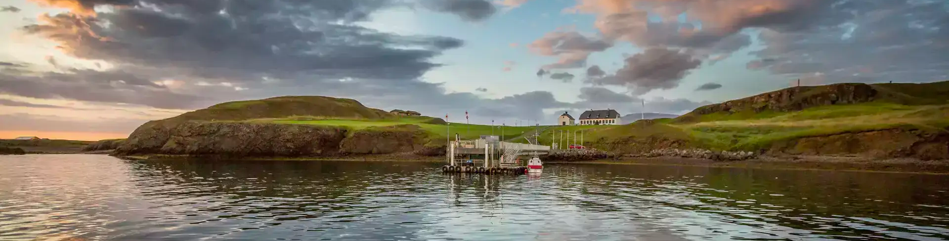
Theme 7 – Viðey Island
A Central park in the sea
Viðey island is a unique natural pearl in the urban landscape. It is a place of historical and cultural importance, with views to all directions, complex natural habitat, and rich connection with the sea. The island has been a popular destination for residents and tourists alike and serves as a centre for cultural activities, nature experience and outdoor life. The story of residence in Viðey can be traced back to the Commonwealth Age (930 – 1262 CE). In 1225, a monastery was founded on the island, operating until 1539 when it was raided by Danish soldiers during the Reformation. The island, however, remained one of the country’s greatest estates for centuries.
Viðey is comprised of two parts, Vesturey (West Island) to the north-west and Heimaey (Home Island) to the south-east. Heimaey is home to some of the oldest and most significant buildings in the country, the church Viðeyjarkirkja and Viðeyjarstofa, which was completed in 1755 as official residence for the first Icelandic Treasurer of the country, Skúli Magnússon. In 1986, the Icelandic state gave the buildings to the City of Reykjavík to commemorate the 200th anniversary of the city. They are now open to the public and house a historical exhibition, a restaurant, and other facilities.
We depart from Reykjavík downtown harbour and talk about the history of urban development along Reykjavík’s northern seafront as we sail to the island. We will also talk about the city’s complex relationship with the sea, ranging from fisheries to recreation. We will then walk around the island, hear stories from the past and get some insight into future plans for the island and the city.
Theme 8 – Science Park
Networking Point for Innovation
The UI Science Park was established by the University of Iceland in 2004. The Park is a partnership between the University (94,6%) and the City of Reykjavík (5,4%). The objective of the partnership is to strengthen research and development in the field of science and innovation, by offering facilities on the University’s campus intended for collaborative actions, networking, outreach and engagement activities.
The UI Science Park’s goal is to facilitate an open environment for companies and institutions, where the synergistic effects arising in creative interactions between research institutions and the business sector can prosper. The Park supports innovation and entrepreneurial operations, it builds bridges between academe and the business sector and, thereby, is supporting value creation for societal development.
Walking tour from the University of Iceland through the UI Science Park. Visitors will learn about the organisation and development of the area, and we get 1-2 presentations by partners to this establishment.
Picture: https://english.hi.is/collaboration/ui_science_park
Theme 9 – Appointment with local conditions
Brownfield redevelopment / BRT-lines / Salvation Army headquarters
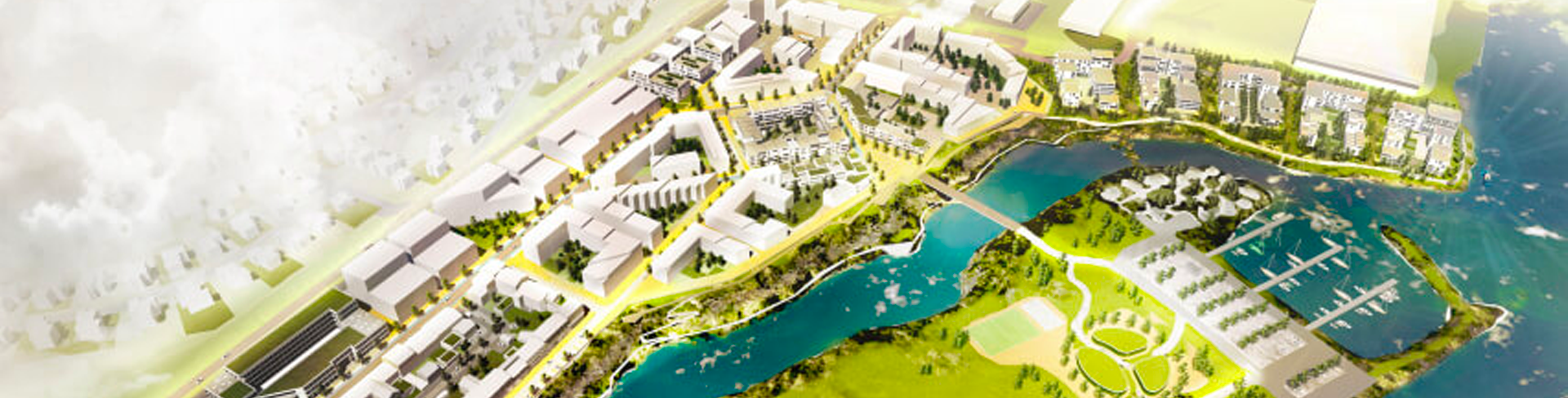
Vogabyggð waterfront transformation from industrial site to a resilient neighbourhood, is the first large development area that the City of Reykjavík launched under the auspices of urban densification in accordance with the 2014 “Reykjavík Central Plan 2040”. The development of apartments and street reconstruction in the area is now nearing completion. The site is around 200.000m2 with 18.000 dwellings and 50.000m2 mixed-use offices, leisure, retail, preliminary school, kindergarten and neighbourhood centre. A competition has now been announced for a new kindergarten and primary school in Vogabyggð which will be located in the existing outdoor area on Geirsnef peninsula.
The area lies close to the eastern part of Laugardalur valley and the Elliðaárvogur inlet with connection to the sea as it is surrounded by coastline and preserved water banks from the last ice age. Here you can find beaches, mudflats and low cliffs, as well as a dock for sport boats, mixed with the panoramic view. A river estuary flows by which means that wild salmon and trout migrate through the mudflats up Elliðaá river in spring and summer. This new neighbourhood will be connected with the greater capital area by the implementation of BRT lines. The new Vogabyggð will also be linked with the older Vogar to the east, built in the 1950s and 60s. The plan is to merge the two districts with a covered deck on top of the Sæbraut main road—a cut-and-cover tunnel.
Starting with a bus ride from The University. The walk starts at the westernmost part of the new Ártún neighbourhood area (area 2), then a walk crossing the pedestrian bridges through Geirsnef peninsula and Vogabyggð, ending at the Salvation Army new headquarters.
Picture: https://www.felixx.nl/projects/redevelopment-strategy-vogabygg.html
Theme 10 – The Pearl necklace in Öskjuhlíð green area
Þráinn Hauksson, landscape architect and project manager at Landslag will guide this trip. The group will meet by The Pearl (Perlan). Perlan resembles a pearl sitting on top of Reykjavík. It is surrounded by the charming woodland of Öskjuhlíð hillock, with 360° views all over the capital area. We will walk around Öskjuhlíð and look at the construction of the so-called “Pearl Necklace”, a winning proposal of a hiking trail from Landslag which is currently under construction. The author of the proposal will tell us about it.
The design incorporates accessibility for everyone (including wheelchair access) and the group will visit interesting places in Öskjuhlíð. The walk will cover historical monuments, but a part of the design is to preserve them and mark with signs and information. The eastern part of the woodland, towards Fossvogur Cemetery, will become a suitably scattered birch wood with large open areas, where flowering vegetation, willow and rowan trees can be enjoyed with the associated bird life. At the same time, the meadow west of the Pearl will stay the same. The winning proposal shows great sensitivity to vegetation and nature experiences in this green area, which is popular for recreational activities, including running, hiking, dog-walking and cycling.
Theme 11 – Redevelopment of Reykjavík´s historic centre
From past to present
A walkshop through the biggest transformation area of the city, right in the historical centre of Reykjavík.
The harbour and coastline are the spots where Reykjavík initially became a township and, in recent years, the area has grown into a modern urban centre. These latest developments are adding a new layer to the history of Reykjavík, especially its relation to the oceanfront.
The walk will take you from the old harbour to Harpa music hall. Passing through Tryggvagata, Hafnartorg and Austurhöfn, with a stop at the municipal library in Grófarhús which will be renovated in the coming years.
We will walk through the points of friction where recent history meets the past, walking through and discussing different scales of development over time and the reasons behind design decisions. Technical solutions and other factors have influenced both design and non-design that we find within the area, looking into the past and looking into the future. Finally, we will discover how one little hot dog stand can sometimes be the most influential actor.
The walk will tell the story of big ideas, collaboration and construction leading upto the banking crisis in 2008, and what we learned in the aftermath.
Picture: https://visitreykjavik.is/city-areas
Theme 12 – Urban gardening in the north
This walkshop will provide an overview of the history of urban gardening in Reykjavík. A visit to the Ræktunarstöð, a plant nursery run by the city, and a visit to a vegetable plot, leased and maintained by residents.
Plant nursery has been part of the city's operations ever since the sixties. It was in Laugardalur until 2000 when it was moved to Fossvogsdalur when the city bought a nursery owned by Reykjavík’s forest organisation.
The area in Laugardalur became the Botanical Garden and a public park.
The nursery in Fossvogsdalur only produces plants for the city, trees, shrub and all the ornamental plants for flower beds and pots.
The goal is to produce plants that are suitable for the climate in Reykjavík. Conditions for vegetation are often harder in exposed green areas and in streets, than in sheltered gardens.
Knowledge about the surviving species is growing all the time and there is ongoing communication between the gardeners of the nursery and the gardeners who maintain vegetation on city-owned land.
Near the nursery is one of the residential vegetable plots. The area used to be for children to learn how to grow eatables, but the programme was cut in the aftermath of the 2008 economic crisis. There is a tradition in Iceland of growing vegetables, especially potatoes, however, urban farming decreased significantly as the availability and variety of vegetables grew in the grocery stores and storage facilities at home improved. After the 2008 crash, improving one’s household finances by growing eatables became a popular idea and the interest to lease a plot grew, even though many people did not know how to grow vegetables.